Aerial view of the Sverdrup Glacier, a river of ice that flows from the interior of the Devon Island Ice Cap (Canada) into the ocean. Image by: Alex Gardner, Clark University
Sea-level rise caused by anthropogenic climate change poses an existential threat to coastal cities worldwide. By 2100, the IPCC projects a global mean sea-level rise of between 0.3 and 1.0 metres under moderate scenarios, with some estimates reaching 2 metres under extreme conditions, given Marine Ice Cliff Instability in Antarctica and accelerating melt dynamics in Greenland. For the hundreds of millions of people living in low-elevation coastal zones, lives and livelihoods are at risk. This article overviews both realised infrastructure and speculative design proposals inspired by terraforming, from history to today, in the context of combating sea-level rise.
Terraforming or Earth-shaping is the hypothetical process of intentionally modifying the atmosphere, topography and other systems of a planetary body. While Elon Musk proposes nuking Mars’ poles to release CO₂, heat the atmosphere and melt the ice, there have been ideas of terraforming Earth itself, especially put forth by Benjamin Bratton during his tenure at the Strelka Institute before the Russian invasion of Ukraine. Bratton’s The Terraforming (2019) prompted the question: why is humanity not actively engaging in geoengineering projects such as building mountain ranges out of sequestered CO₂, the Carbon Range, to capture rain where needed, or blasting a crater to make space for the volume of sea level rise, instead of blowing up communities? Without surprise, the idea is not original.
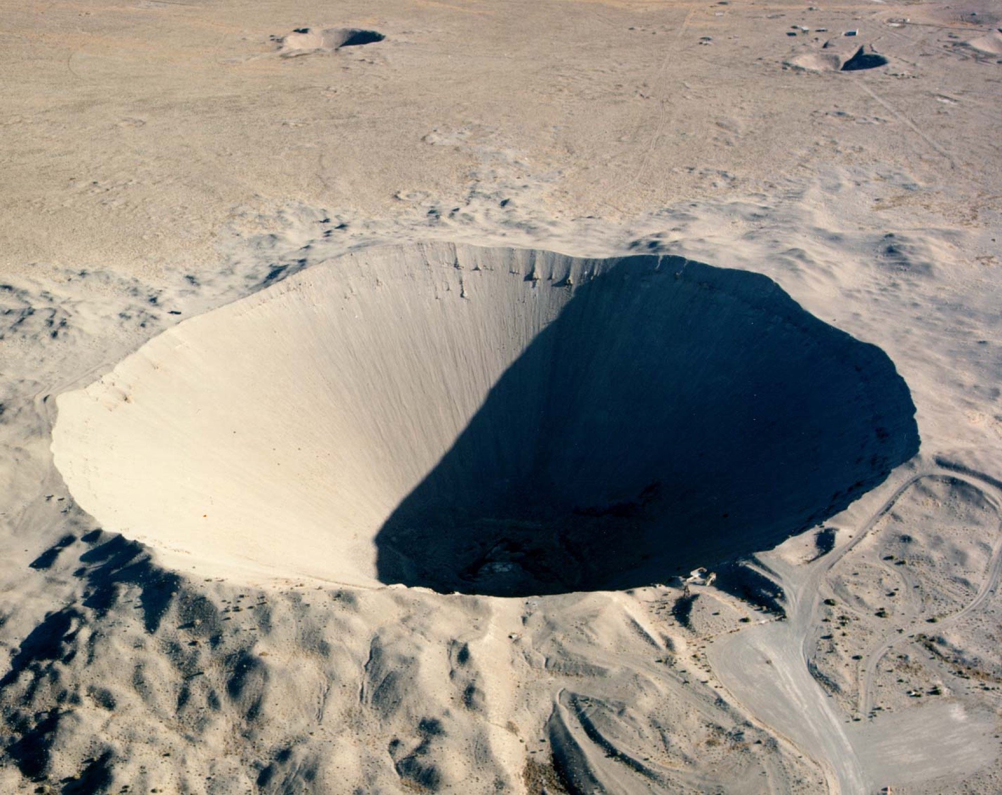
From a historical perspective, the United States Project Plowshare employed Peaceful Use of Nuclear Explosives (PUNE) through the U.S. Army Engineer Nuclear Cratering Group, which conducted research in Nevada using nuclear explosives for civil engineering in the 1960s. Their aim was to widen the 82-kilometre Panama Canal. However, a single 104-kiloton underground detonation, as in the case of the Sedan test, produced a crater only 100 metres deep and less than 400 metres wide. Besides the problems with public relations, as Jordan Coulombe writes in Searching for Stability: Energy, Entropy, and the Abandoning of the Panatomic Canal, the experiments in Nevada would not translate to Panama. The crater slopes were not stable in a landslide-prone humid landscape, and the imprecision of nuclear excavation was far too great to continue.
Sedan crater from the PUNE Plowshare project, 1962. Image by: Federal Government of the United States.
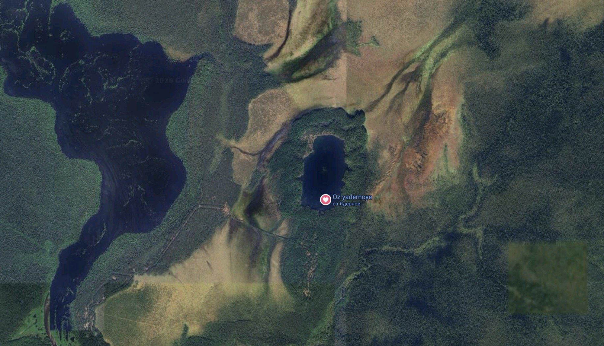
Similarly, the USSR attempted to use nuclear explosions to construct the 112-kilometre Pechora-Kama Canal in the Perm region in 1971, part of the larger Northern River Reversal project, which aimed to redirect Siberian rivers draining “uselessly” into the Arctic Ocean southward, to irrigate fields and refill the drying Aral and Caspian Seas. Three 15-kiloton devices were detonated simultaneously, producing a chain of craters approximately 700 metres long and 350 metres wide, now filled with water and known as the Atomic Lake. To complete the canal, the USSR would have needed to detonate roughly 250 such devices. The project was abandoned in 1986, and the site remains radioactively contaminated.
Atomic Lake from Taiga experiment in Perm, Russia (1971).
With atomic detonations producing such a small geoengineering impact relative to their ecological one, these projects were above humanity’s reach. To illustrate the scale of the problem: global sea level has risen approximately 20 centimetres since 1880, with the rate now accelerating to 5.9 millimetres per year as of 2024. The worst-case NOAA trajectory, under average temperature rises exceeding 4 degrees Celsius, projects up to 2 metres of rise by 2100, including thermal expansion of ocean water. This represents a volume of approximately 720,000 km³ (AI-calculated) of additional water in the ocean system.
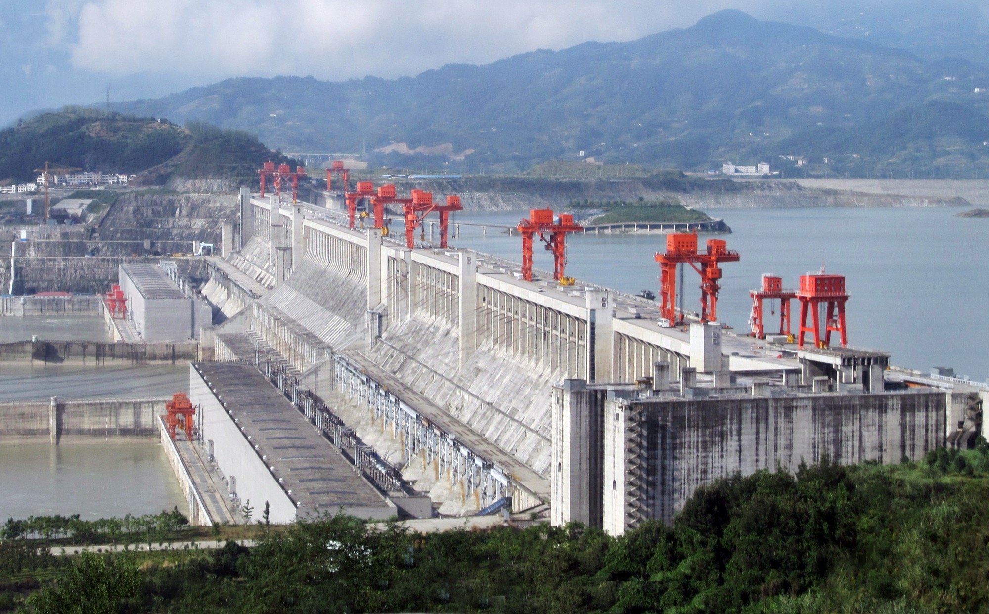
To put that in engineering terms: the Chinese Three Gorges Dam, built on the Yangtze River, is the largest hydroelectric structure in the world, holding 39.3 km³ of water. The mass of that reservoir is sufficient to slow Earth’s rotation by 0.06 microseconds and shift the rotational axis by approximately 2 centimetres. These numbers sound sensational, but the natural seasonal variation in rotation is 17,000 times greater. The scale of sea-level rise itself changes Earth’s rotation: from 2000, the redistribution of water mass from melting ice sheets and glaciers is estimated to lengthen the day by 13.3 microseconds per year, and the pole has shifted approximately 366 metres from where it sat a century ago against a natural seasonal wobble of about 3 centimetres. The Three Gorges Dam, a remarkable engineering achievement preventing flooding downstream and generating 22,500 megawatts of electricity, is a drop in the ocean against the scale of terraforming capabilities of humanity, however unwanted those are.
The Three Gorges Dam on the Yangtze River, China. Image by: Rehman.
A structure needed to retain the full volume of 2-metre sea-level rise would require excavation that diminishes anything humanity has produced. Detonating every currently active nuclear warhead simultaneously underground would produce roughly 180 km³ of displaced rock. The needed volume is 724,000 km³. That leaves us short by a factor of 4,000 times the entire current global nuclear arsenal.
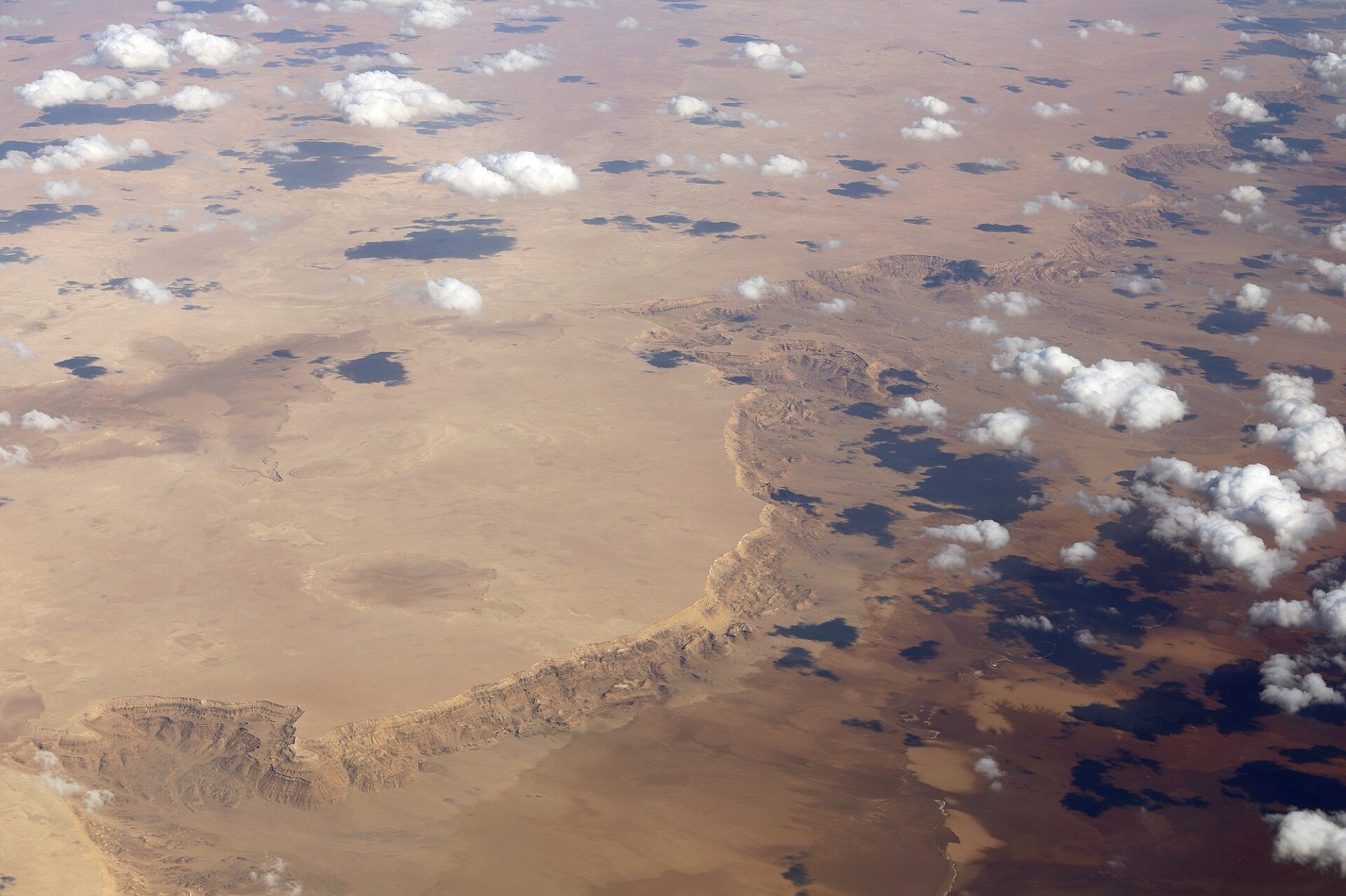
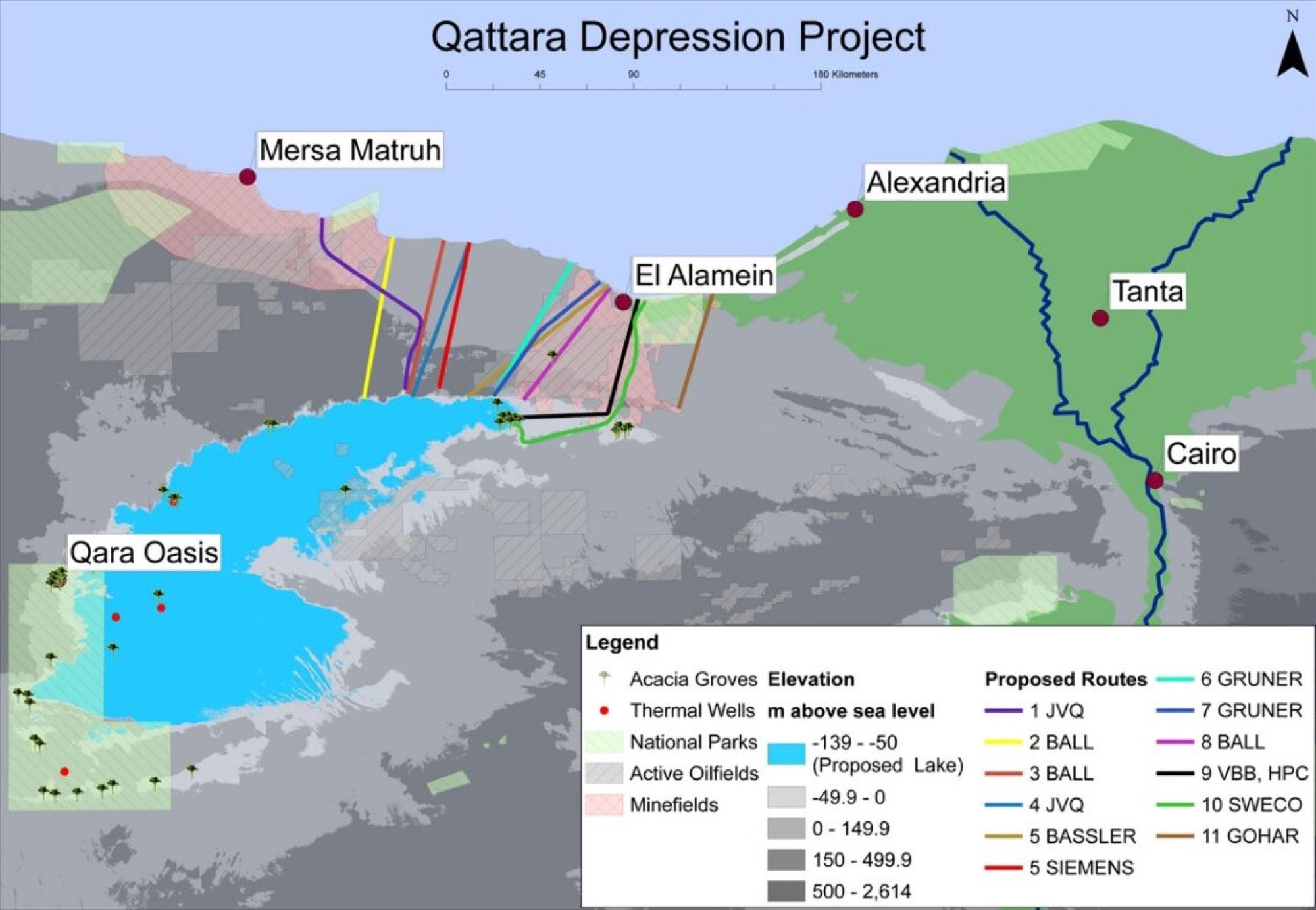
Yet might reflooding emptied basins do something? The Qattara Depression in western Egypt lies between 50 and 133 metres below sea level, covering approximately 20,000 km², and was targeted for refilling as early as the 1920s, inspired by Jules Verne’s novel Invasion of the Sea. The original proposal called for a canal from the Mediterranean to slowly release water into the basin, producing hydroelectricity from the elevation drop, while hot desert conditions caused rapid evaporation, enabling continuous inflow and potential salt production and water desalination as co-benefits. The project proved too difficult and too expensive to execute in the 1930s.
Qattara Depression, Egypt. Image by: Marc Ryckaert.
Sea-level rise has given new incentive to revisit this idea. Amir AghaKouchak, Professor of Civil and Environmental Engineering and Earth System Science at the University of California, Irvine, and Editor-in-Chief of the journal Earth’s Future, leads the Inland Sea Reflooding research programme, funded by the ARC Initiative. In an interview, he explains Inland Sea Reflooding is “the reconnection of large, below-sea-level basins to the ocean to create stable inland seas,” with many candidate sites being former marine embayments that became isolated by tectonics, sedimentation or shoreline change, and later dried. In practical terms, reflooding would use a sea-level inlet on the Mediterranean connected to Qattara via canals or tunnels, with flow regulated to ensure stability, energy opportunities during initial filling, and environmental protection.
Image source: Wikimedia.
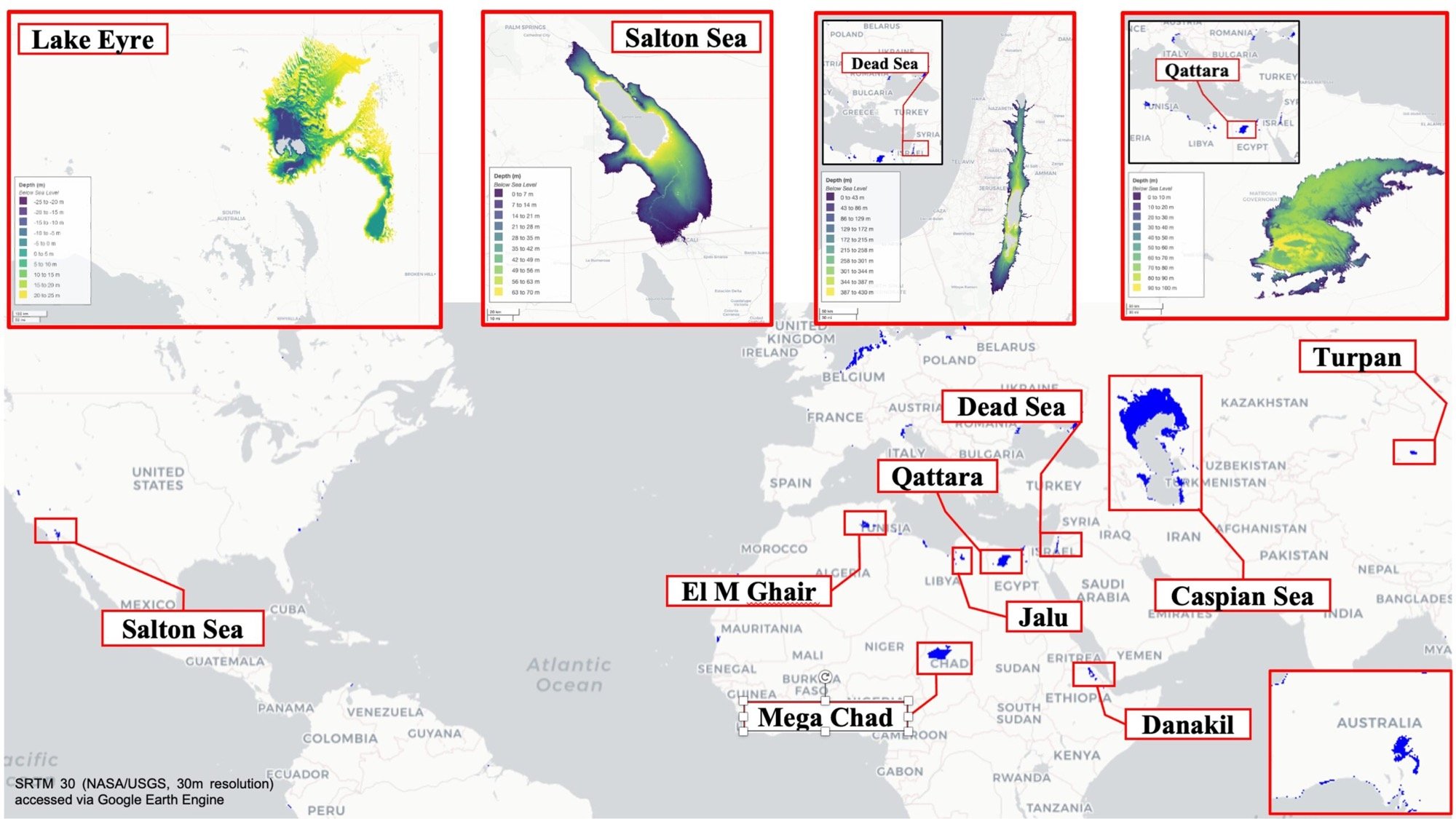
AghaKouchak’s team used NASA topography data to map more than a dozen candidate basins worldwide. Qattara alone is comparable in volume to Lake Ontario and could slow global sea level rise by approximately 2 centimetres, at a cost on par with New Orleans’ post-Katrina levees and less than half the cost of the Three Gorges Dam. Lake Eyre (Kati Thanda) in Australia holds three times the capacity of Qattara, with a potential 7-centimetre sea-level offset, though partnership with the Arabana indigenous people would be essential. The Danakil Depression in Ethiopia and Eritrea is described as geologically ideal, with added geothermal energy potential, though geopolitical tensions would require careful consideration. Evaporation from a flooded Qattara basin could further slow expected sea-level rise by as much as 5%, and there may be 5 to 10 other depressions worldwide suitable for similar treatment.
Potential targets for inland sea reflooding. Image courtesy of Amir AghaKouchak.
AghaKouchak’s is careful to frame the concept as a research programme rather than an engineering plan, stressing that its scale, irreversibility, and long-term consequences require extensive scientific evidence, environmental assessment, and governance before any action is taken. Even combining all viable basins, the total volume removed from the ocean would account for a fraction of the 720,000 km³ problem. This is not a solution. It is, at best, a contribution measured in centimetres against metres.
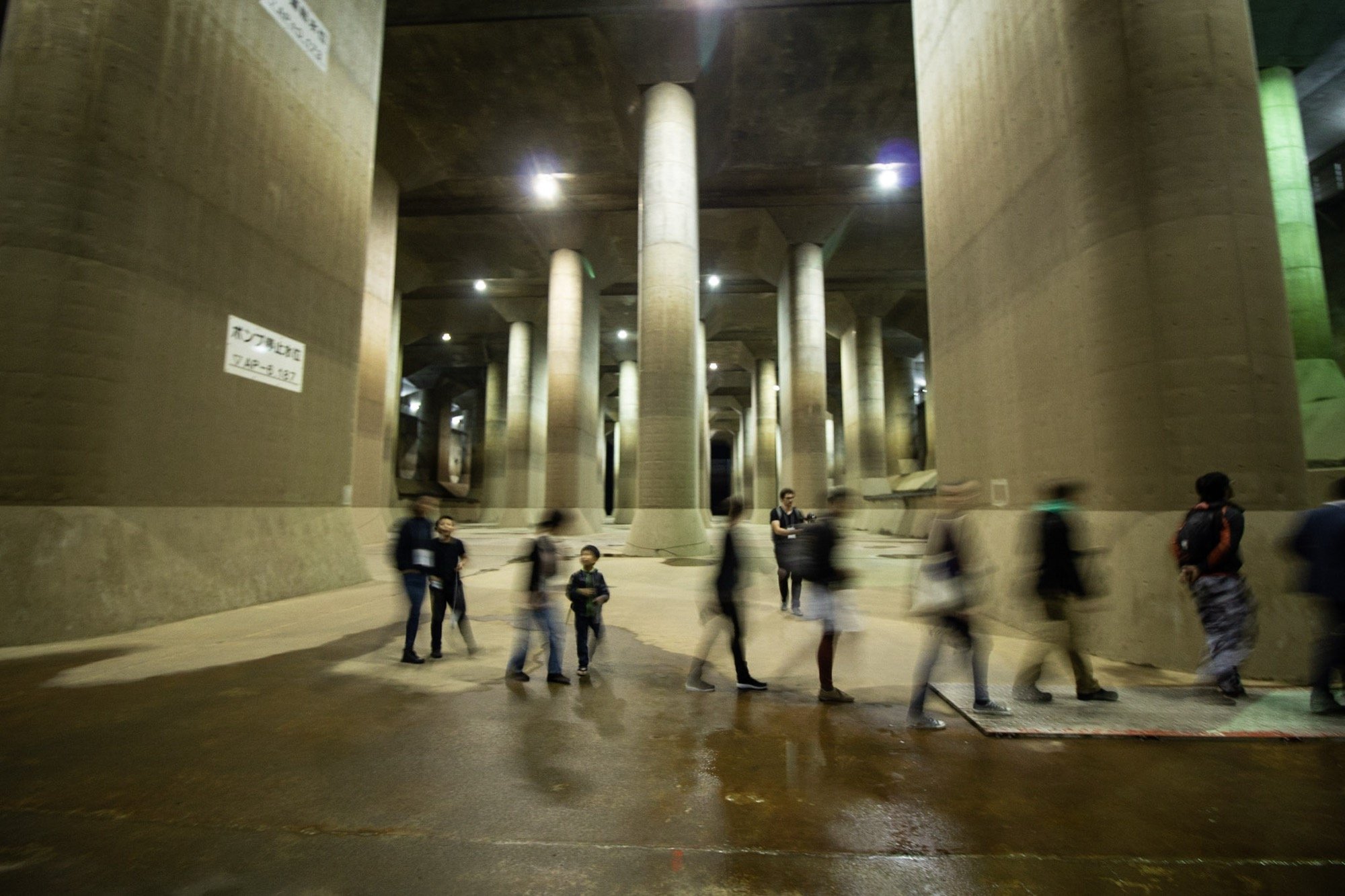
Which returns us to what cities are actually doing. Tokyo built the Metropolitan Area Outer Underground Discharge Channel, a system of five shafts 32 metres in diameter connected by 6.4 kilometres of tunnels 50 metres underground, discharging floodwater at 200 tonnes per second into the Edo River. Manhattan’s BIG U proposes a 16-kilometre landscaped berm and deployable barrier system around the lower tip of the island, turning flood infrastructure into public parkland. Rotterdam built water squares, public plazas that flood deliberately during storms and drain slowly, turning extremity into urban everyday. The Netherlands has the Delta Works; Jakarta, one of the most endangered cities, moved its capital. Where ecosystems remain, nature-based solutions, mangrove forests, salt marshes and living shorelines provide wave attenuation and sediment accumulation at low cost and high ecological yield.
Metropolitan Area Outer Underground Discharge Channel, Japan. Image by Ubahnverleih.
The energy released daily by burning fossil fuels, which warms the atmosphere, melts the ice and raises the sea, makes any bomb we could deliberately detonate negligible. It seems this was merely a mental exercise, throwing us back upon ourselves, arriving at the sobering conclusion that humanity is the terraforming event. Against that, local and ecological responses may appear insignificant, yet they remain among the few forms of agency available to us.
To provide the best experiences, we use technologies like cookies to store and/or access device information. Consenting to these technologies will allow us to process data such as browsing behavior or unique IDs on this site. Not consenting or withdrawing consent, may adversely affect certain features and functions.
Functional
Always active
The technical storage or access is strictly necessary for the legitimate purpose of enabling the use of a specific service explicitly requested by the subscriber or user, or for the sole purpose of carrying out the transmission of a communication over an electronic communications network.
Preferences
The technical storage or access is necessary for the legitimate purpose of storing preferences that are not requested by the subscriber or user.
Statistics
The technical storage or access that is used exclusively for statistical purposes.The technical storage or access that is used exclusively for anonymous statistical purposes. Without a subpoena, voluntary compliance on the part of your Internet Service Provider, or additional records from a third party, information stored or retrieved for this purpose alone cannot usually be used to identify you.
Marketing
The technical storage or access is required to create user profiles to send advertising, or to track the user on a website or across several websites for similar marketing purposes.
To provide the best experiences, we use technologies like cookies to store and/or access device information. Consenting to these technologies will allow us to process data such as browsing behavior or unique IDs on this site. Not consenting or withdrawing consent, may adversely affect certain features and functions.
Functional
Always active
The technical storage or access is strictly necessary for the legitimate purpose of enabling the use of a specific service explicitly requested by the subscriber or user, or for the sole purpose of carrying out the transmission of a communication over an electronic communications network.
Preferences
The technical storage or access is necessary for the legitimate purpose of storing preferences that are not requested by the subscriber or user.
Statistics
The technical storage or access that is used exclusively for statistical purposes.The technical storage or access that is used exclusively for anonymous statistical purposes. Without a subpoena, voluntary compliance on the part of your Internet Service Provider, or additional records from a third party, information stored or retrieved for this purpose alone cannot usually be used to identify you.
Marketing
The technical storage or access is required to create user profiles to send advertising, or to track the user on a website or across several websites for similar marketing purposes.